GreenStart

GreenStart's mission is to foster a resilient energy and food system for New Hampshire by providing technical education and practical agricultural examples. An educational non-profit organization established in 2006, GreenStart sees food and fuel security as the end-product of a vibrant, sustainable agriculture system in New Hampshire.

New Hampshire has 40% of its land area in agricultural soils, yet farms only 10% and imports 95% of its food and fuel. New Hampshire has no significant petroleum resources. To feed and fuel itself from sustainable natural resources, New Hampshire must improve its soils while also improving production.

To achieve this end, GreenStart facilitates projects that
1) increase soil carbon “banking”
2) decrease energy inputs
3) increase both food and fuel outputs (positive energy and carbon balance)
4) promote “tight” cycling of nutrients
5) provide opensource access to appropriate knowledge, seeds and equipment

Location: 
Lee  New Hampshire
United States
Open Shop Tools
Stage: Ready to Build
Type:
Universal farm infrastructure/farm shop, Harvesting, Planting, Soil management
# of Topics: 10
Last Tool Wiki Update 10/14/2024
# of Wiki Edits: 23
Stage: Concept
Type:
Universal farm infrastructure/farm shop, "Smart Farm" tools
# of Topics: 5
Last Tool Wiki Update 09/13/2024
# of Wiki Edits: 36
Stage: Prototype
Type:
Universal farm infrastructure/farm shop
# of Topics: 4
Last Tool Wiki Update 06/04/2024
# of Wiki Edits: 19
Stage: Ready to Build
Type:
"Smart Farm" tools
# of Topics: 70
Last Tool Wiki Update 09/03/2015
# of Wiki Edits: 24
Stage: Concept
Type:
"Smart Farm" tools
# of Topics: 0
Last Tool Wiki Update 08/05/2015
# of Wiki Edits: 12
Stage: Commercial Product
Type:
Planting, Soil management, Water, Energy
# of Topics: 2
Last Tool Wiki Update 07/01/2015
# of Wiki Edits: 23
Stage: Prototype
Type:
Energy
# of Topics: 2
Last Tool Wiki Update 03/22/2015
# of Wiki Edits: 12
Stage: Ready to Build
Type:
Soil management, Planting
# of Topics: 2
Last Tool Wiki Update 03/02/2015
# of Wiki Edits: 6
Stage: Prototype
Type:
"Smart Farm" tools
# of Topics: 0
Last Tool Wiki Update 02/05/2015
# of Wiki Edits: 2
Stage: Prototype
Type:
"Smart Farm" tools, Universal farm infrastructure/farm shop
# of Topics: 3
Last Tool Wiki Update 01/15/2015
# of Wiki Edits: 12
Stage: Prototype
Type:
"Smart Farm" tools, Harvesting, Irrigation and Water Management, Planting, Pollinators / Honey, Post Harvest, Season extension, Soil management, Crop storage, Water, Energy, Universal farm infrastructure/farm shop
# of Topics: 13
Last Tool Wiki Update 09/17/2014
# of Wiki Edits: 2
Stage: Ready to Build
Type:
"Smart Farm" tools, Universal farm infrastructure/farm shop
# of Topics: 4
Last Tool Wiki Update 09/04/2014
# of Wiki Edits: 39
Stage: Ready to Build
Type:
Post Harvest
# of Topics: 6
Last Tool Wiki Update 07/03/2014
# of Wiki Edits: 19
Stage: Concept
Type:
Harvesting
# of Topics: 3
Last Tool Wiki Update 03/16/2014
# of Wiki Edits: 15
Stage: Prototype
Type:
Universal farm infrastructure/farm shop
# of Topics: 2
Last Tool Wiki Update 03/07/2014
# of Wiki Edits: 5
Stage: Prototype
Type:
Harvesting
# of Topics: 0
Last Tool Wiki Update 01/27/2014
# of Wiki Edits: 5
Stage: Concept
Type:
"Smart Farm" tools, Crop storage, Harvesting, Post Harvest, Universal farm infrastructure/farm shop
# of Topics: 0
Last Tool Wiki Update 11/16/2013
# of Wiki Edits: 1
Stage: Concept
Type:
# of Topics: 3
Last Tool Wiki Update 10/14/2013
# of Wiki Edits: 5
Stage: Commercial Product
Type:
Energy, Universal farm infrastructure/farm shop
# of Topics: 1
Last Tool Wiki Update 06/10/2013
# of Wiki Edits: 3

Events Hosted

Forum Comments from Organization's members
dorn's picture

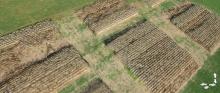
We will actually be cutting two one meter samples in each plot, sorting the biomass,drying it and then weighing it. Which is why if we could find a remote way to calculate these values, we could save many many hours of labor.

I think that we might be able to get some rough information on biomass based on growth height which could probably be extracted based on the known scale of the plots and the heights of the plots above the pathways which is a known ground level. It would be interesting to see what kind of resolution we do have.

We will be doing the ground based measurements within the next two weeks, so we could correlate the on the ground data anytime after that is entered.