Hello Farm Hackers I'm Melissa Brandao in Oregon and I'm new here. I would be interested in getting your feedback on applications/needs/wants for a unmanned aircraft, specifically hover, low-flight helicopters or hover craft. We are working on a demonstration project here in Hood River and we would like it to be as relevant to micro/premium Ag farmers as possible, but it's not going to be focused on the high flight aerial photos. We are looking at low-flight hover craft applications. Please contact me here or @theladyelectric Thank you!

Join the conversation! The forum activity is now at GOATeach.org! We are working to cross pollinate our conversations. Document and share tools at farm hack and talk at GOAT! Also join GOAT riot and introduce yourself and your projects!
Hi Melissa, Welcome to Farm Hack! There is a lot of interest in using aircraft (and balloons and kites) to get aerial imagery for management and research purposes. There is an event in May in collaboration with public labs for the second year in a row focusing on how to best use open source imaging tools for agricultural purposes. More information can be found here
http://farmhack.net/forums/ifarm-imaging-agricultural-research-and-manag...
There is also a tool wiki to focus on the development and use of on farm imagery which I am sure you could add to as well -
http://farmhack.net/tools/ifarm-imaging-agricultural-research-and-manage...
Please feel free to edit and add to the wiki or starting some forum threads from the tool to kick off some more detailed discussion.
I am especially interested in the NDVI and spectrometry potential for rapid assessment of crop performance. There are some researchers here at UNH who are looking at using the spectrometer to get early warning of pests in orchards, and I am particularly interested in gathering data similar to what a Spad meter asses percent cover, identify species composition, and generate estimates of crop height.
I think that rapid data gathering is key to being able to implement adaptive farm management. Look forward to the dialog.
Inspecting fields. Counting cattle/goats/livestock. Checking for downed fence lines. Checking water, mineral trays, ...
Of course, you would need video on the UAV, and a high-speed data/video connection to its camera.
Weather is the biggest challenge - it can't be used in moderate wind or gusty conditions. So a fairly good "localized weather" station system might be in order too. Another challenge might be areas of high pollen concentration - depending on the drive mechanism for the UAV.
What we found is if we have to go to the field anyway, then we might as well do the inspection ourselves rather than fool with setting up and packing away a UAV. Having a fixed, computer controlled flight path for a large field might make it more worthwhile - but then there's problems with RC radio range.
Melissa, I would start with using a large pole with a camera atop, especially for small fields. I just ordered a 36' carp fishing pole that collapses to 4' long. http://www.allfishingbuy.com/Fishing-Pole/Pole-A1-114-3-12011.htm
I got it after testing a DIY 30' bamboo pole that was heavy and difficult to move around, but still produced some decent images: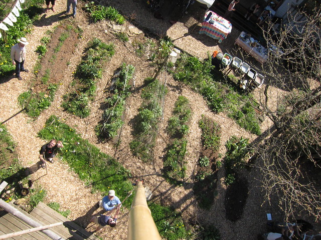
I work with Public Lab and have a big stock of kites and balloons too, and would love an excuse to to head out to Hood River. DM me on Twitter @headfullofair
Wow, guys! Awesome! I love the picture from the pole! May is really soon so I don't know if I can make the NH event--what about having one here in Oregon in the fall? There is plenty of know-how and interest in seeing this technology used in the great work of farming!!
I'm really hoping we can keep the discussion going, what I am finding thus far in my research of research initiatives is a lot of spectral imagery but what smaller, lighter an less costly systems can we build that would be useful and applicable to the farm?
I'm in Portland and have a lot of equipment. I'd ove to connect to more agriculture folks who want to do NDVI or other photo trials in Oregon. I'd be up for doing something sooner, and trying to track a plot over the spring and summer.
I'm in Portland and have a lot of equipment. I'd ove to connect to more agriculture folks who want to do NDVI or other photo trials in Oregon. I'd be up for doing something sooner, and trying to track a plot over the spring and summer.
Hi Mathew
great to hear you're local are you farming? let's noodle on some ideas, I've got some folks here in the Gorge that would be willing candidates for tests
http://store.publiclaboratory.org/collections/spectrometry/products/fold...
It seems that lot of the work is getting these low cost spectrometers calibrated to plant tissue and soil sample analysis. The more robust version is only $40 - http://store.publiclaboratory.org/products/desktop-spectrometry-kit
this is a great way in to start developing open data sharing that is being discussed in this tool wiki
http://farmhack.net/tools/open-farm-data#forum
to start to develop calibration standards and assign some meaning to data coming out of this kind of technology.
There is also this sandboxed tool that tries to get at how to pull in this kind of data and make it useful to farmers and researchers alike.
http://farmhack.net/tools/universal-adaptive-management-software#wiki
Would be great to tie it into this kind of software too
http://farmhack.net/tools/crop-planning-software
Did you guys see this? http://www.data.gov/food/page/events
open sourced data from the Gov--why does this kind of initiative make me so uncomfortable...