Aerial mapping rigs

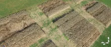
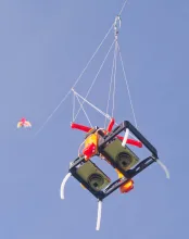
These lightweight rigs hold small cameras (e.g., Canon PowerShots) for lofting by kites or balloons. Vertical photos can be taken at intervals as the rig is moved around a property and high resolution orthophotos can be made by stitching together...
I built (or modified) this tool
No votes have been submitted yet.
0 comments
Created: 2015/12/04 03:03
Updated: 2024/09/13 19:16

IFARM (Imaging For Agricultural Research and Management)

By dorn
Using low cost balloons, kites, UAVs etc. to create overhead, NDVI images, and spectroscopy for practical agricultural applications. IFARM (Imaging For Agricultural Research and Management)
I built (or modified) this tool
No votes have been submitted yet.
0 comments
Created: 2012/05/24 12:46
Updated: 2024/11/18 14:16